UgCS Integrated Systems provides a range of invaluable software packages to enable safe, effective and efficient flight missions. Please contact us if you are considering purchasing UgCS software to support your missions with or without sensors.
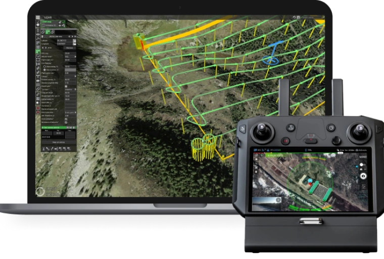
UgCS Expert LIDAR Toolset
The UgCS LIDAR toolset unlocks the full potential of LIDARs enabling effective remote sensing without human error. Delivers everything that UgCS Pro delivers plus LIDAR capabilities.
- Save time on mission planning with flight patterns and turns designed specifically for LIDAR surveys
- Acquire high-quality laser data with preset IMU initialization patterns and anti-shake LIDAR turns
- High accuracy of acquired data ensures getting desired results with one trip to the field
Supports most popular LIDAR platforms: DJI, YellowScan, Riegl, PhoenixLIDAR, LIDAR USA, GeoCue, Rock Robotics, & GeoSun LIDAR
FREE Trial: Try before you buy with a 14 day free trial.
UgCS Pro
World’s leading Ground Control Software for UAV Drones
Safe and efficient toolset for UAV land surveying and industrial inspections. LIDAR, Magnetometer, GPR, automatic Area, Photogrammetry, Corridor, Vertical, and SAR survey planning tools with custom elevation data import and terrain following mode.
Supports most popular UAV platforms: UgCS DJI M350, M300, M200, M600, Inspire, Phantom 4, Mavic and series, Parrot and Mavlink compatible Pixhawk/APM.
UgCS Enterprise
Live Video Feed Features
All the features and benefits of UgCS Pro.
Benefit from a live video stream from UgCS for DJI to UgCS
(currently compatible only with Win & Android)
- Multiple SDK connections
- ADS-B Transponder
- Compatible with UgCS Mapper to perform live video mapping.
UgCS Mapper
Create Maps offline with UAV Drone Photogrammetry
Mapper is a lightweight software tool for making 2D maps and elevation out of drone imagery and video – purely offline.
Increase surveying productivity – validate the quality of dataset – collected images are suitable for map stitching, before leaving the survey area.
Higher flight safety – create up to date 3D map and elevation data, i.e., when default map sources are not accurate enough for safe mission planning.
UgCS ATLAS AI
ATLAS Optimses Drone & Satellite Geospatial Data Analysis
ATLAS leverages AI to automate time-consuming manual analysis of UAV & Satellite data, such as object counting, volume measurements, making a true DTM, and much more.
ATLAS contains its own AI-engine, which learns from users activity and automates regular data analysis tasks.
ATLAS can be taught to identify changes of assets, components, and geospatial data over time, to support various monitoring, inspection, and integrity activities.

Custom Integration & Software
UAS Integration & Custom Software Services
UAS integration services allow combining various technologies, sensors and cameras with automated airborne systems.
SPH Engineering is your partner for building, acquiring and consulting on the selection of airframes, autopilots, payloads for a particular application and performing proof of concept projects and required software development for complete integration.
SPH Engineering has vast experience in ground control software development and on-board control software development,and a well-known UgCS enterprise
UgCS Commander
UgCS Commander, birden fazla İHA görevini paralel olarak yönetmek için basit ama güçlü bir araçtır. Yer kontrol UgCS yazılımının alternatif bir istemcisi olarak çalışır ve DJI’ın tüm popüler drone’larını ve Ardupilot veya Px4 tabanlı sistemleri destekler.
UgCS yazılımının bu kullanışlı sistemi, farklı drone üreticilerinin (DJI ve DJI olmayan), çoklu rotorların, helislerin ve sabit kanatların birden fazla drone’unun, önceden planlanmış manevraları gerçekleştirerek herhangi bir yönden herhangi bir bireysel rota ile senkronize uçuşunu yönetir.
Bu UgCS yazılımı, karşı drone taktiklerinin etkinliğini test etmek için tasarlanmıştır.
Drone Show
Drone Show Yazılımı, binlerce drone’u uçan pikseller gibi kontrol ederek şaşırtıcı açık hava gösterilerini yönetmeye yönelik araçlar sağlar.
SPH Engineering’in bu drone sistemi, uçuşlarını ışıklar, havai fişekler, duman jeneratörleri ve diğer faydalı yüklerle yöneten, piyasada satılan ilk yazılımdır.
Drone Show Yazılımı, drone’ları, tutkusu ve koreografı olan herkesin akıllara durgunluk veren drone gösterileri oluşturmasına olanak tanır.
Pek çok eğlence endüstrisinde halihazırda oldukça değerli olan devrim niteliğindeki drone gösterisi kontrol yazılımıyla etkinliklerinizi bir sonraki seviyeye taşıyın.
Learn More About UgCS Drone Software
Learn more about UgCS Drone control software.